
Top 10 mountains and Peak in Sri Lanka
written by Lasi

Sri Lanka is highly renowned throughout the world for its stunning mountains and the surrounding natural beauty that they bring. There are numerous rocky summits and peaks scattered throughout the country's center and south. These locations are ecologically diverse and have great ecological value. There are well-preserved forest areas in Sri Lanka's mountains, and many of the country's rivers originate there as well. Pilgrims from all over the world travel to Sri Lanka's Sri Pada Mountain to worship the footprint of Lord Buddha. This nation is known across the world for its tea plantations and is also home to several waterfalls.
Low temperatures and nearly constant weather are characteristics of this nation. The country's distinctive features, which include enormous mountains covered in rich vegetation and occasionally punctuated by waterfalls, give it a stark beauty. Mountains and breathtaking sightseeing opportunities in Sri Lankan towns like NuwaraEliya are what make the nation exceptional.
01. Adam's Peak or Sri Pada
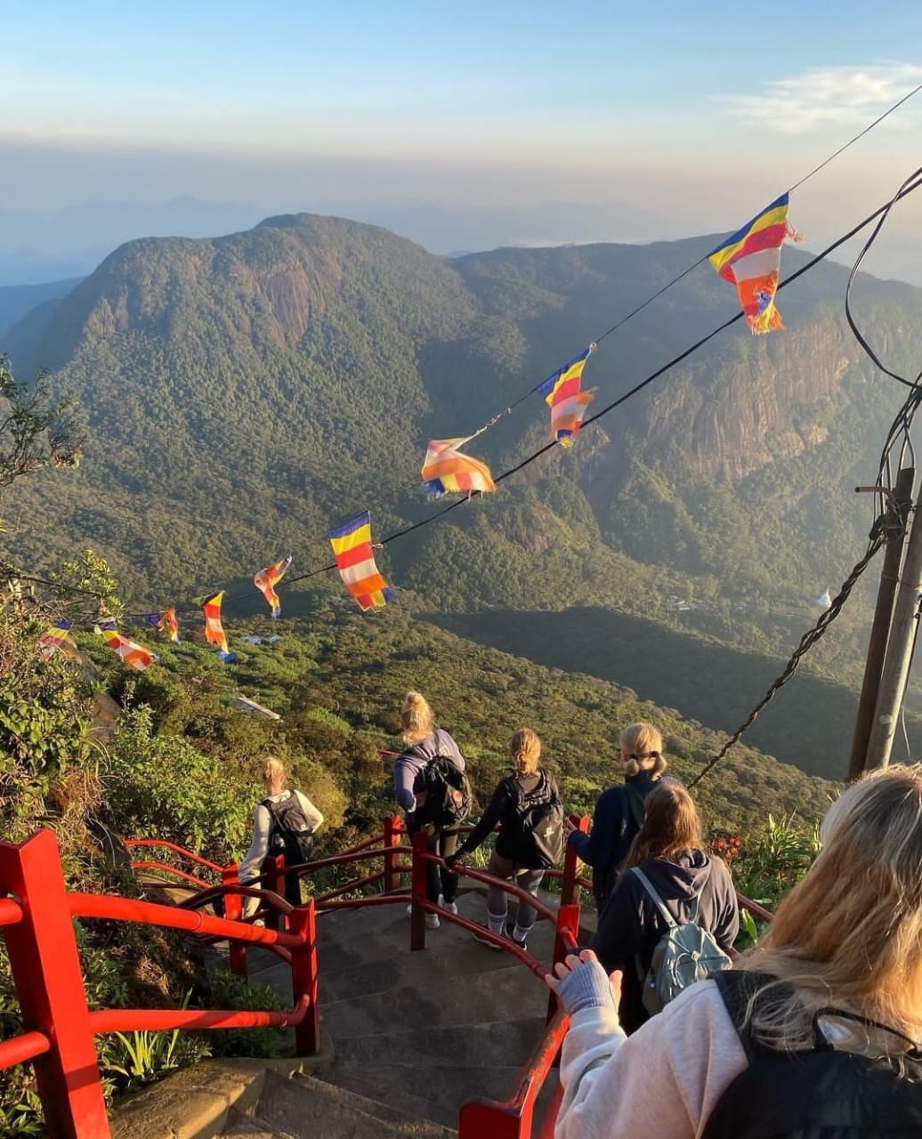
As was already mentioned, the Buddhist pilgrimage to Sri Pada in Sri Lanka is highly renowned. Near the top of Adam's Peak, which rises to a height of 2,243 meters, is a 1.8-meter rock structure known as Sri Pada or the sacred footprint. Many different religions converge on this mountain, including Buddhism, which sees it as the footprint of Buddha, and Hinduism, which sees it as the footprint of Lord Shiva. This footprint is thought to be that of Adam or Saint Thomas in both Islam and Christianity. One of Sri Lanka's most stunning mountains, Adam's Peak is situated in the district of Ratnapura on the periphery of the central massif. In comparison to the majority of other mountains, the region's surrounding group of mountains, known as Wilderness of the Peak, is substantial.
Adam's Peak Pictures more

.jpeg "Adam's Peak in Sri Lanka")
02.Pidurutalagala Mountain in Sri Lanka

The tallest mountain on the island, Pidurutalagala Mountain in Sri Lanka (literally, Straw Plateau Rock), is also known as Mount Pedro in English. It is located in the Central Province, northeast of the town of Nuwara Eliya. It is also one of just 1515 highly conspicuous peaks in the globe and the only one on the island. A mountain with topographic prominence (the height of the peak's summit above the lowest contour line encircling it up to the highest summit) above 1500 meters is referred to as an ultra prominent peak. The prominence of Mount Pedro is 2524 meters (8281 feet) above sea level (8292 feet according to the Survey Department).
Pidurutalagala Mountain is surrounded by a forest preserve. Five years ago, a forest fire caused damage to the area, resulting in the loss of 3 acres of woodland. With the aid of nature and human intervention, the damage is currently being healed. Due to the fact that the government and armed forces of Sri Lanka use the summit to house their communications network, the mountain and forest reserve region has been declared as an area of extremely high security.
03.Kirigalpotta

04.Thotupolakanda peak

The third highest peak in Sri Lanka, Totapolakanda (also spelled Thotupolakanda or Thotupola Kanda), is located in the Nuwara Eliya area at 2,357 m (7,733 ft) above mean sea level. In the Horton Plains National Park, the mountain is situated. A few meters from the Pattipola gate to Horton Plains National Park, a two-kilometer walk up to the mountain's summit begins. Shrubs adapted to the chilly, windy climate of Horton Plains National Park dominate the majority of the mountain surface. They frequently include species of Strobilanthes, Osbeckia, and Rhodomyrtus that are grown as shrubs.
In the Sinhala language, Totapolakanda means "Landing Site" and is associated with the Rama and Ravana mythology. Rama, the legendary king of India, and his stunning bride Sita supposedly lived in exile in the wilderness. Ravana once abducted Sita, the wife of Rama, and fled to Sri Lanka. The first stop on the flight to Sri Lanka was Totapolakanda, which means "landing location."
05.Knuckles Mountains Range

Knuckles Range access
The main highway A26, which runs east of Kandy to Hunnsgiriya, is where hikers like to access the Knuckles Ranges. A B grade road from Hunnasiriya leads to Corbett's Gap, which provides breathtaking views of the Knuckles range. A car with good ground clearance can also drive the road from Corbett's Gap to the settlement of Meemure.
The trekkers also have two additional entry routes to choose from: one from Wattegama via Panwila and the other from Matale via Rattota and Riversten. The rough peaks of the Knuckles, also known as the Dumara Hills, were given that name by the British because they resembled the knuckles of a closed fist. The main Knuckles peak, the sixth-highest peak in Sri Lanka, is located 1863 meters above sea level and is surrounded by a rare stand of dwarf cloud forest.
Knuckles Range's Mini World's End
A good observation spot in the Knuckles range is Mini World's Extremity (1192m), an escarpment located near the southern end of the mountain. From here, one may see a panoramic view of the Knuckles Range and some of the communities located in its foothills. One hour is needed to complete the 1.1 kilometer hike that starts at the Knuckles Conservation Centre (KCC) in Deanston.
Peaks of the Knuckles Range Mountains
34 summits in the Knuckles mountain range have elevations between 1900 and 900 meters. The British in Ceylon named the mountain range Knuckles because its five tall mountain summits resembled a clinched fist.
06.Hanthana mountain

People who enjoy hiking, camping, bird watching, and any other form of being in close proximity to nature are drawn to the Hanthana mountain range in Kandy.
Local lyricists have also captured the magnificent beauty and serenity of these mountains in song.
The Hanthana mountain range, which is 1240 meters above sea level, extends 20 kilometers south of the town of Galaha from Kandy.
The Mahaweli river receives its water from freshwater springs on the western end of Hanthana, and the river's tributaries divide the range's several hills.
There are seven distinct peaks in all, with Ura Kanda being the highest.
Spectacular views of Kandy city, the Knuckles range, the dolosbage range of Aranayake, and the hills are available from the peaks.
07.Namunukula

The most noticeable peak in this Uva tea region is Namunukula. There are paths that lead to Namunukula mountain's plateau. The easiest one splits off close to the pass that connects Passara and Spring Valley. There is only one road that passes through Spring valley, making it simple to locate the pass. Simply take the B97 through Demodara, turn left at the store in the middle of Spring Valley, and continue along this side road nearly to the summit. Before you get to the pass, the hiking trail splits off to the left about 300 meters. It's a difficult steep trip uphill, but the ascent doesn't require any climbing expertise.
08.Bible Rock

You don't always have the chance to see Bathalegala, also known as the renowned Bible Rock, from such a unique perspective. On our approach up or down the Kadugannawa Pass along the Kandy Road, we typically view it from a distance as a gloomy square sentinel standing over other rock and mountain. It is a distinctive aspect of the landscape that rises 2,618 feet above sea level and is regarded as a charming landmark that has always been a challenge to painters, poets, and photographers.
Because it resembles an open book when seen from the British-built Kandy Road, this rock was given the name Bible Rock during the British Period.
After leaving Mawanella, we continued on the beautiful Hathgampola Road. We were initially unsure of the nature of the rock because we were unfamiliar with the area and were pursuing an unrelated attraction when it would occasionally loom over and dominate the nearby planes.
09.Gombaniya

The country's Matale area is home to the Gombaniya range. The range is also known as the Knuckles range because it has five peaks that resemble the knuckles of a closed fist. This range's highest point is located at a height of 6,248 feet above mean sea level. From West to Southeast, the Gombaniya range's five peaks—also referred to as the Mini-Alps—are Kirigalpotta, Gombaniya, Knuckles, Koboneelagala, and Dotulugala. This mountain range spans an area of about 20,000 hectares. It is a must-visit location on your journey to Sri Lanka because it is home to a range of native plants and animals from the Indian subcontinent.
10.Kudahagala NuwaraEliya

Kudahagala Mountain, also known as Agrabopat Hills, has been determined to be the fourth-tallest mountain in Sri Lanka. Its elevation is 2320 meters (7,612 feet). This mountain is located close to the Nuwara Eliya district and is readily seen from the nearby Horton Plains National Park.